Program for the Study of Developed Shorelines
Science. Policy. Education. Outreach. Coastal.
Yellowstone Infrastructure Vulnerability
This study developed a protocol for assessing the natural hazard vulnerability of assets at Yellowstone National Park, and evaluates the vulnerability of a subset of assets (191 buildings, 34 parking lots, 26 bridges, 78 miles of roads, and 17 miles of trails) to six key natural hazards (flooding, stream channel migration/erosion, geothermal activity, wildfires, landslides, and earthquakes).
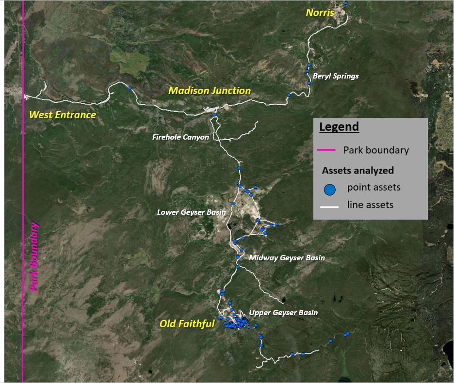
The project study area encompasses the West Entrance, Madison Junction, Norris, and Old Faithful areas (see image to the right).
The primary goals of this project were to:
1. Present the asset vulnerability assessment protocol and methodologies developed for each natural hazard and asset type at Yellowstone,
2. Present the results of the asset vulnerability assessment conducted, including exposure, sensitivity, and final natural hazard vulnerability,
3. Provide a synthesis of overall infrastructure vulnerability in the study area, across all six selected natural hazards.
Summary of Results & Discussion
Results of this analysis show more assets in the study area are exposed to wildfires and earthquakes than any of the other evaluated hazards at YELL, largely due to the widespread nature of these hazards. This is likely to be the trend for these two hazards across the entire park. Flooding, stream channel migration/erosion, geothermal activity, and landslides are more spatially limited by proximity to the hazard source (e.g., rivers, geothermal basins, and steep slopes), and therefore affect fewer assets. Although there is widespread exposure to wildfires and earthquakes across the study area, some asset types have relatively low sensitivity to these hazards. For example, roads, trails, and parking lots are less likely to be significantly damaged by wildfires or earthquakes, when compared to buildings and bridges.
Using this protocol, flooding (riverine and surface runoff) is the most significant hazard in the study area of YELL in terms of total value. A significant portion of this value is from bridges, which are commonly built across water bodies, and inherently exposed to river-related hazards such as flooding. Therefore, the sensitivity of these bridges is extremely significant, as efforts to reduce sensitivity (e.g., proper sizing to accommodate storm event flows) are often the only way that vulnerability to flooding can be reduced for these assets. Finally, the study area selected coincides with some of the larger geothermal basins in the park, which can have complex hydrology. As a result, the flooding hazards in these areas includes surface runoff due to geothermal activity.

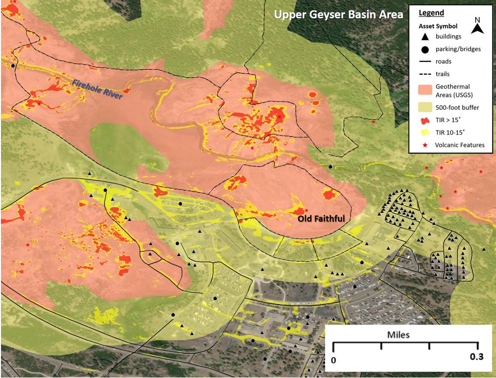
Geothermal activity is particularly important within Lower, Midway, and Upper Geyser basins. While the percentage of assets with high vulnerability to geothermal hazards is relatively low, a significant number have moderate vulnerability (55% of all point assets and 23% of all road and trail lengths). The relatively low vulnerability to geothermal hazards reflects the efforts by NPS to balance safety with visitor access to geothermal attractions. Future planning for infrastructure (e.g., rerouting of trails or boardwalks) can be aided through the regular use of fixed-wing TIR data, which can be used to precisely map the geothermal hazards and volcanic features, as well as changes in activity.
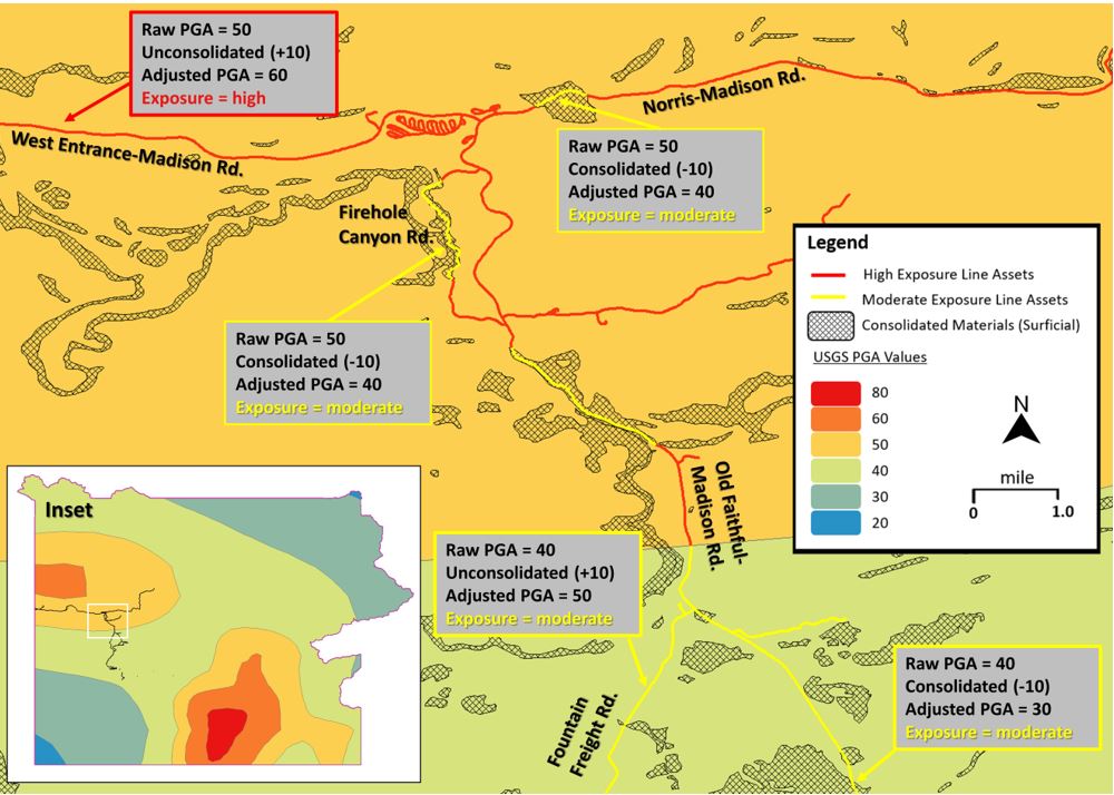
Earthquake hazards are also significant throughout the study area, in terms of both percent and value. Almost one-fifth of all point assets and one-third of road/trail mileage have high vulnerability to earthquakes using this protocol, the highest fractions of any hazard. In a seismically active national park, it is difficult to avoid exposure to earthquakes. Therefore, most earthquake adaptation strategies for assets at YELL should be asset-specific and primarily address sensitivity (e.g., use of earthquake-resistant construction materials).
Wildfires primarily affect buildings and bridges (road and trail) in the study area, which are more vulnerable than roads, trails, and parking lots. While wildfire exposure is widespread across much of the park, there are few roads, parking lots, and trails with high vulnerability, due to low sensitivity. In a national park with a strong natural resources mission and tradition, it can be difficult to modify landscapes or reduce fuel loads in order to lessen wildfire exposure. Therefore, most wildfire adaptation strategies for assets at YELL will likely be site- or asset-specific (e.g., reducing brush near buildings or replacing roofs with non-flammable materials).
Stream channel migration/erosion is most significant for roads and bridges in the YELL study area. While the percentage of road length with high vulnerability is relatively low (6%), each of the primary road corridors (West Entrance to Madison Junction, Norris to Madison Junction, Old Faithful to Madison Junction) has multiple segments with high vulnerability to stream channel migration/erosion. For example, the Norris-Madison Road has 26
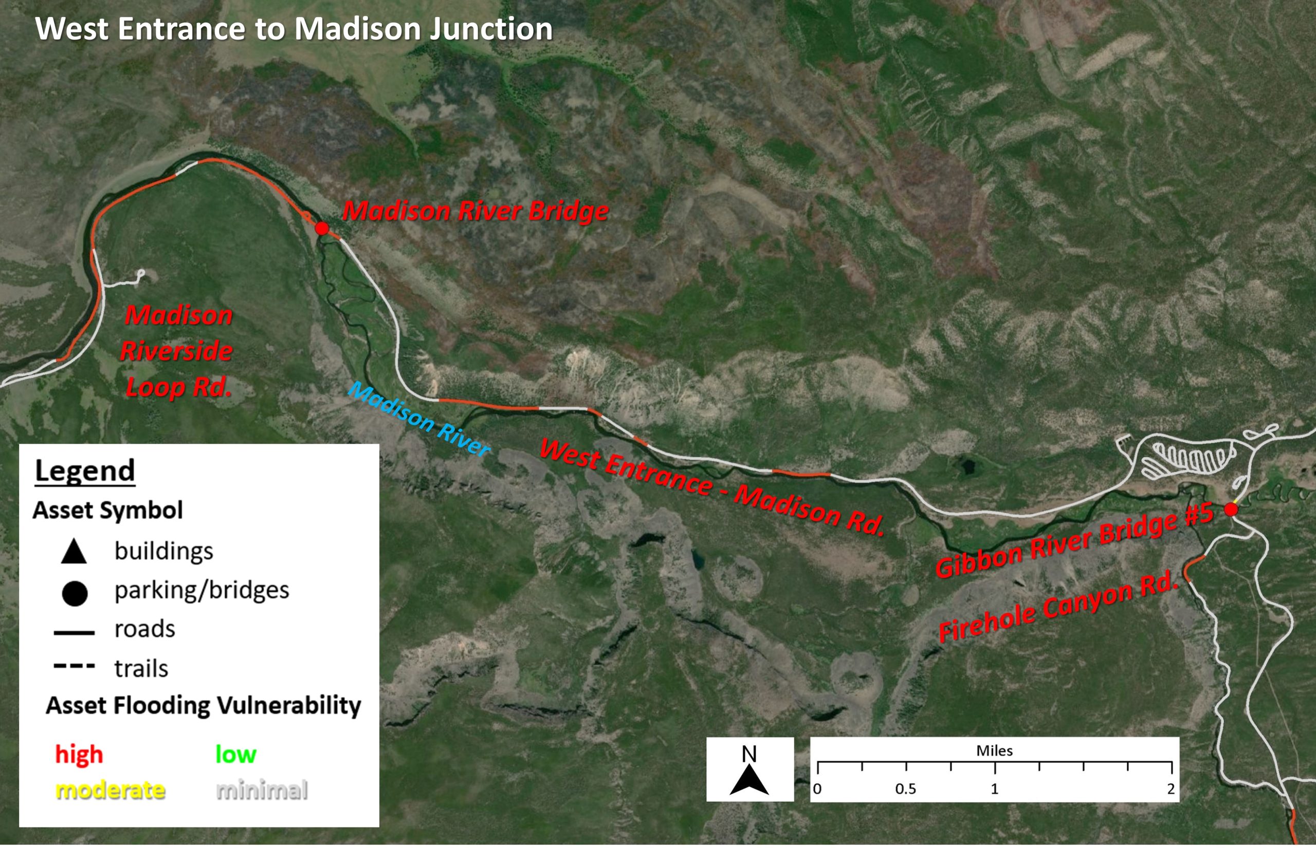
segments with high vulnerability using this protocol; worsening erosion or sudden shifts in the stream channel at any one of these hotspots (or near a bridge) could cause major access and traffic issues in this part of the park. It would benefit the park to monitor these segments, or conduct more detailed analyses, to determine if adaptation action is warranted.
Landslides are less significant in the YELL study area, as none of the evaluated point assets or trails have high vulnerability, and only 1% of the road length has high vulnerability. These results are a factor of the study area landscape, as only a few specific areas have steep-walled canyons or nearby slopes (e.g., Firehole and Gibbon canyons). Similar to stream channel migration/erosion, the road mileage with high vulnerability to landslides in the study area is relatively low. However, it is important to note again that even a small section of road damaged by landslides could cause major problems and delays.
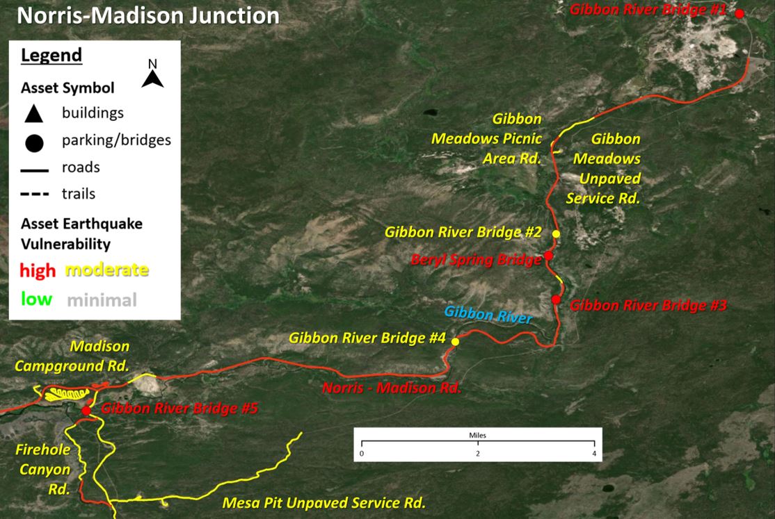
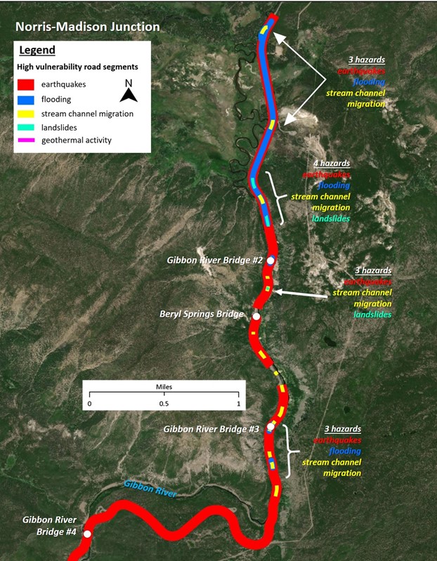
Many assets in the study area of YELL are highly vulnerable to multiple natural hazards, several of which have significant value and/or priority to the park. These assets may provide a good starting point for developing adaptation strategies in this area of YELL. Only one building has high vulnerability to four hazards but has a relatively low value and priority to the park. Several buildings have high vulnerability to three of the evaluated hazards. The West Entrance to Madison Junction and Norris to Madison Junction road corridors have the most road segments with high vulnerability to three or more hazards. Along these corridors, there are several key segments/locations that have high vulnerability to a combination of earthquakes, flooding, stream channel migration/erosion, and landslides.
Each of the evaluated hazards is part of a dynamic natural system, which will certainly change over time. Some changes may be readily predictable, with the potential to increase or decrease asset vulnerability, while others may be more complex or interrelated. In addition, changing climate has the potential to amplify these changes, necessitating the periodic reevaluation of asset vulnerability at YELL as new data comes available.
Program for the Study of Developed Shorelines
Old Student Union
Western Carolina University
Cullowhee, NC 28723

