Program for the Study of Developed Shorelines
Science. Policy. Education. Outreach. Coastal.
Town of Duck NC – Vulnerability Assessment
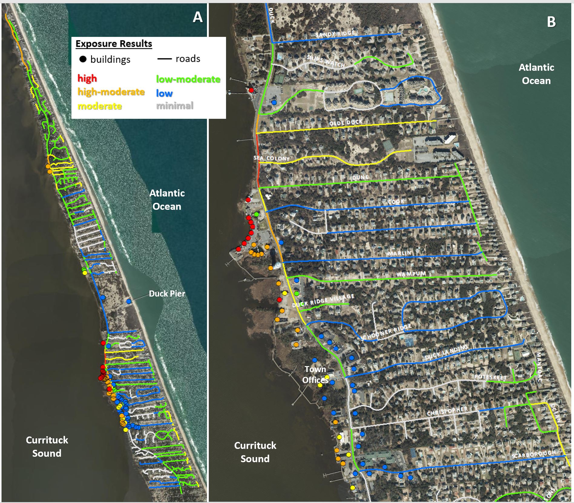
Western Carolina University’s Program for the Study of Developed Shorelines has completed a Coastal Hazards Infrastructure Vulnerability Assessment for the Town of Duck, North Carolina. Vulnerability is generally defined as the extent to which a resource is susceptible to harm from hazards or climate change impacts. For infrastructure (assets), vulnerability is most often calculated as a combination of exposure and sensitivity. Exposure refers to the extent or degree to which climate change or a natural hazard is likely to affect an asset, and sensitivity refers to how it will fare when exposed to a hazard/impact. This assessment evaluated individual buildings and roads, allowing managers to compare the vulnerability of individual assets to develop more detailed adaptation plans and strategies. The coastal hazards evaluated in this study include flooding, storm surge, sea-level rise, and erosion.
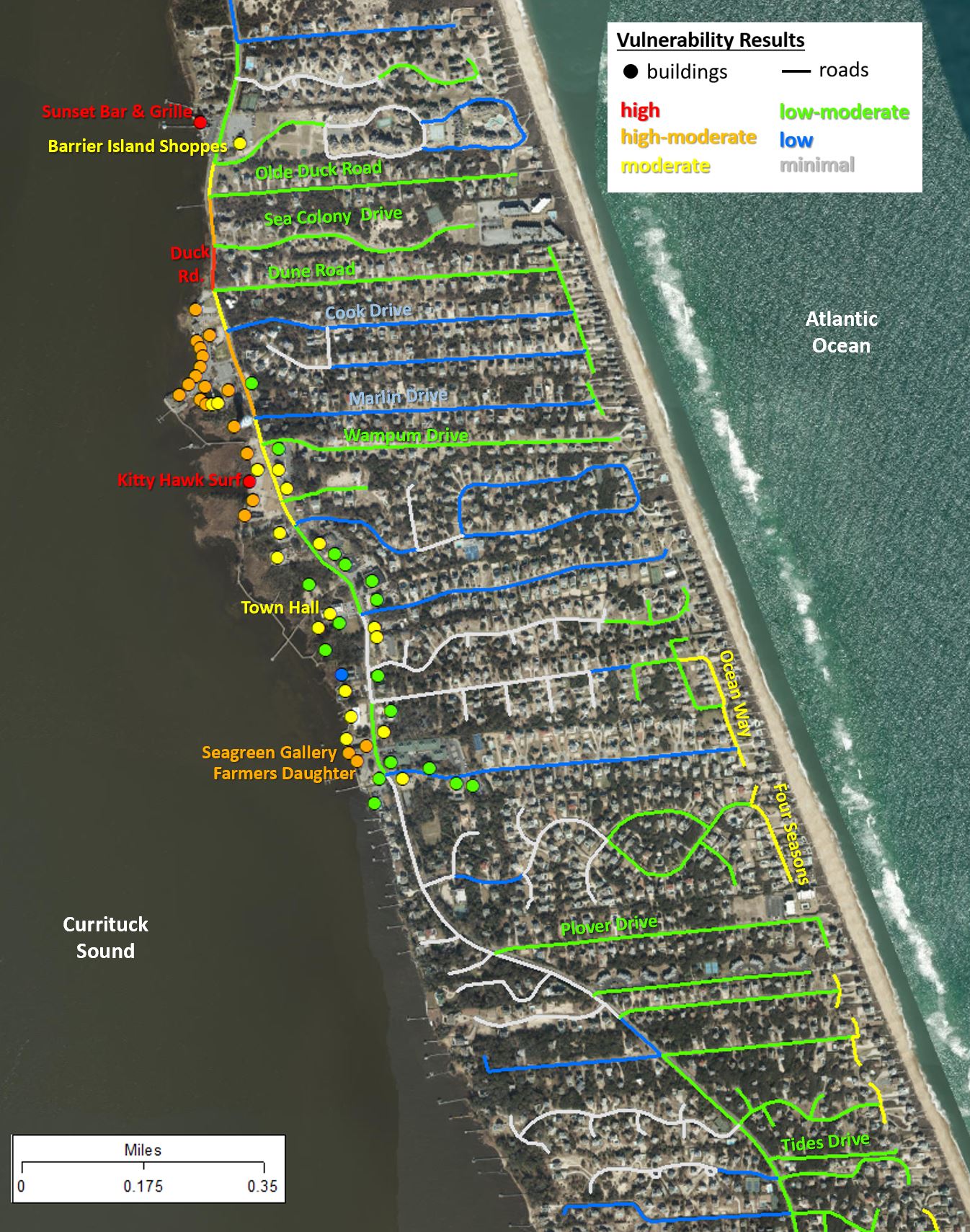
This assessment focused on roads and a subset of commercial, professional, retail, and publicly-owned buildings near the town center. Most of the buildings evaluated are concentrated along Duck Road (NC HWY 12) near Currituck Sound. In total, 65 buildings and 308 road segments (almost 32 miles) were included in the vulnerability assessment.


The three highest vulnerability buildings evaluated are Beach Realty, Sunset Grill & Raw Bar, and Kitty Hawk Surf Company. An additional 20 buildings have high-moderate vulnerability. The parcels containing high or high-moderate vulnerability buildings have an estimated value over $24 million, while the associated buildings have an estimated value over $10.5 million. Almost one-third of the evaluated buildings have moderate vulnerability. An additional 21 buildings have low-moderate vulnerability, while the lowest vulnerability building evaluated is Ocean Atlantic Rentals.The highest vulnerability road segment is a short portion of Duck Road, just north of the Waterfront Shops. An additional 6 road segments (totaling over 1 mile) have high-moderate vulnerability, including several portions of Duck Road. In total, 2.60 miles of road have moderate vulnerability, 13.65 miles of road have low-moderate vulnerability, and 7.31 miles have low vulnerability. Nearly 7 miles of road have minimal vulnerability to coastal hazards (due to lack of exposure).
Compared to many barrier island communities, Duck has relatively low overall vulnerability. This is due to its unique sheltered coastal setting and significant interior elevation. Although Duck has these beneficial factors, it still has significant exposure to coastal hazards: primarily coastal erosion on the oceanfront and flooding on the soundside. Winter nor’easters can also significantly subject this part of the coast to erosion, flooding, and waves over multiple days.
Due to low elevations and soundside shoreline retreat (from loss of wetlands and marsh), much of the infrastructure in the town commercial center is exposed to flooding, erosion, and sea-level rise. Because Duck Road (NC HWY 12) is the only road with a continuous north-south connection, it is the most
critical transportation corridor in Duck. The high vulnerability along several segments of this critical road has significant impacts for the entire town, as well as communities to the north. Recommendations for adaptation along the soundside shoreline include the development of a long-term transportation plan for Duck Road, and strategies that restore or slow the loss of marshes and wetlands (e.g., living shorelines).
The vulnerability of existing structures in Duck can be reduced through two primary adaptation measures: elevation and/or relocation. It is also important to consider reducing the vulnerability of any associated utilities, including coordinating with utility providers on the development and installation of more resilient infrastructure. While these adaptation actions may not always be practical, they are important to consider, as they are the most efficient way to decrease the vulnerability and increase the resiliency of existing infrastructure. These adaptation options should certainly be considered following storms when funds may become available for resilience actions. It is also vital to increase the resilience of any future development in Duck. The safest bet is to place new infrastructure in areas that have minimal exposure to hazards. When that is not possible, adopting higher standards for building elevation and construction can lead to more sustainable infrastructure over the long term.
Program for the Study of Developed Shorelines
Old Student Union
Western Carolina University
Cullowhee, NC 28723

