Program for the Study of Developed Shorelines
Science. Policy. Education. Outreach. Coastal.
Coastal Hazards & Sea-Level Rise Asset Vulnerability
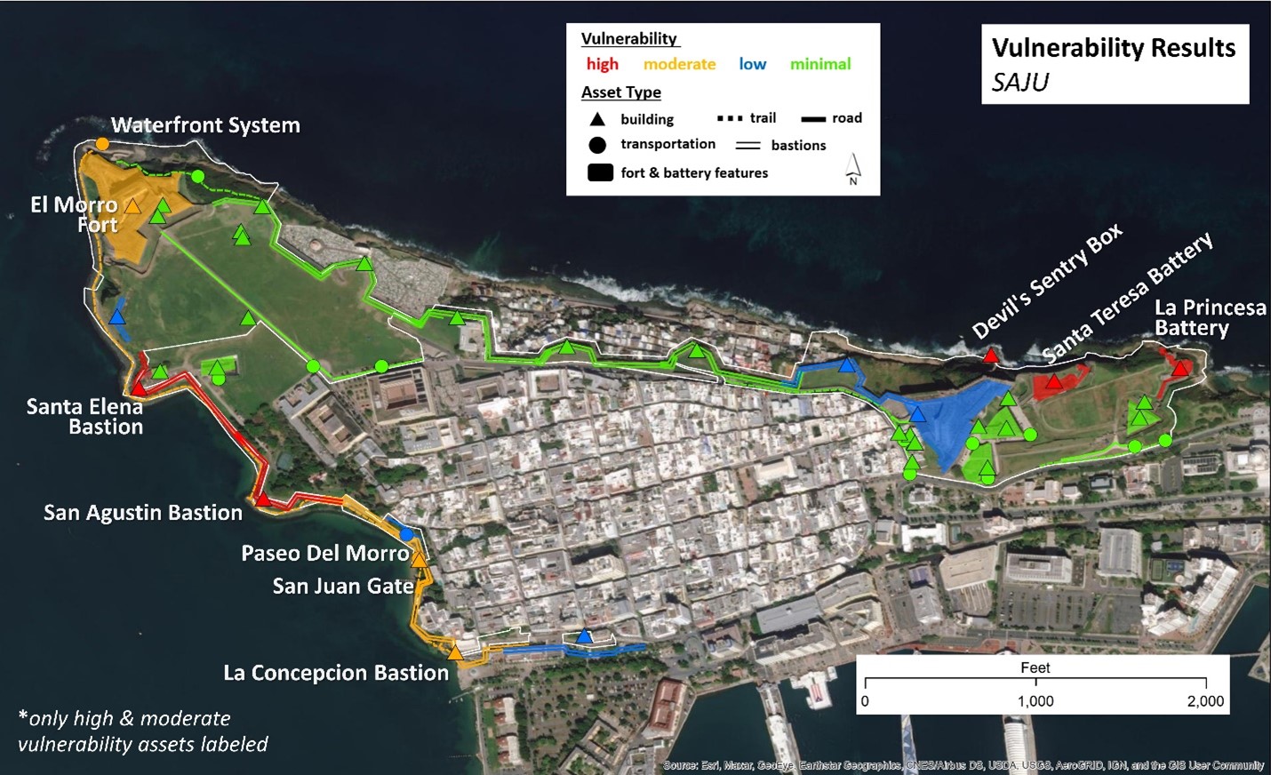
In 2013, the National Park Service initiated a project with the Program for the Study of Developed Shorelines at Western Carolina University to develop a climate change vulnerability assessment protocol for infrastructure in coastal national parks. The Coastal Hazards & Sea-Level Rise Asset Vulnerability Assessment Protocol evaluates the vulnerability of NPS buildings and transportation assets to sea-level rise, flooding, and shoreline change. The overarching purpose of climate change VAs within the NPS is to better understand the degree to which park resources and assets are susceptible to harm from direct and indirect effects of climate change, including variability and extremes. Vulnerability assessments help identify why, where, when, and which resources may be most at risk and help prepare managers for effective adaptation planning
Goals of this project:
• Establish a standard methodology and set of best practices for conducting VAs in the built environment to allow managers to compare the vulnerability of coastal park infrastructure assets across the NPS.
• Provide VA results that are detailed, asset specific, and integrated with other NPS asset management data.
• Evaluate asset vulnerability as a function of exposure and sensitivity.
• Use widely available, established data sources to evaluate asset exposure.
• Provide a comprehensive and objective evaluation of asset sensitivity.
In this protocol, vulnerability is calculated as a combination of exposure and sensitivity, where:
• Exposure refers to whether a resource or system is located in an area experiencing direct impacts of climate change, such as temperature and precipitation changes, or indirect impacts, such as sea-level rise.
• Sensitivity refers to how a resource or system fares when exposed to an impact.
Our vulnerability protocol has now been published!
- Peek, K. M., B. R. Tormey, H. L. Thompson, and R. S. Young. 2022. Coastal hazards & sea-level rise asset vulnerability assessment protocol: Updated project description & methodology. Natural Resource Report NPS/NRSS/CCRP/NRR—2022/2427. National Park Service, Fort Collins, Colorado. https://doi.org/10.36967/2293653 .
PSDS has currently completed vulnerability assessments at over 50 coastal national parks across the United States, including 28 units in the Southeast Region, 21 in the Northeast Region, 3 in the Pacific West Region, 1 in the Alaska Region, 3 in the National Capital Region, and 1 in the Intermountain Region.
Download the park-specific reports below.
PSDS Vulnerability Reports
Southeast Region
Fort Pulaski
Virgin Islands
Dry Tortugas
San Juan
Northeast Region
Saint Croix Island
Boston Harbor Islands
Boston NHP
Assateague Island
Saugus Iron Works
Salem Maritime
Gateway NRA
Harriet Tubman Underground RR
Independence NHP
Thaddeus Kosciuszko
Gloria Dei Church
Edgar Allan Poe
Manhattan Sites
National Capital Region
Intermountain Region
Additional NPS Projects
PSDS has been working with the NPS on projects for over 15 years on a wide range of subjects. Additional NPS projects include:
• Climate change vulnerability assessments in the National Park Service: PSDS worked with a multi-disciplinary team of researchers to identify, review, and evaluate vulnerability assessments that specifically addressed park service units and resources in an effort to improve the agency’s ability to learn from previous studies, to distill “lessons learned”, and identify best practices for designing and conducting these assessments.
• Marine Vulnerability Assessment of Cumberland Island National Seashore: The goal of this project was to develop a methodology framework for assessing the vulnerability of NPS-managed marine habitats, beginning with a pilot project at Cumberland Island National Seashore. This framework employs an assessment approach in which vulnerability is defined as the sum of exposure (the magnitude of the stressor), sensitivity (how strongly a system is affected by the stressor), and adaptive capacity (the potential to adjust in response to the stressor).
• Estimating the Exposure of FMSS-Listed Park Assets to 1 m of Sea-Level Rise: This project focused on identifying NPS assets that may be threatened by a future 1 m rise in sea level within 40 coastal units. A 1 m rise in sea level can be expected to occur in the next 100 to 150 years. Many of the assets identified are already vulnerable to existing coastal hazards (erosion and storms).
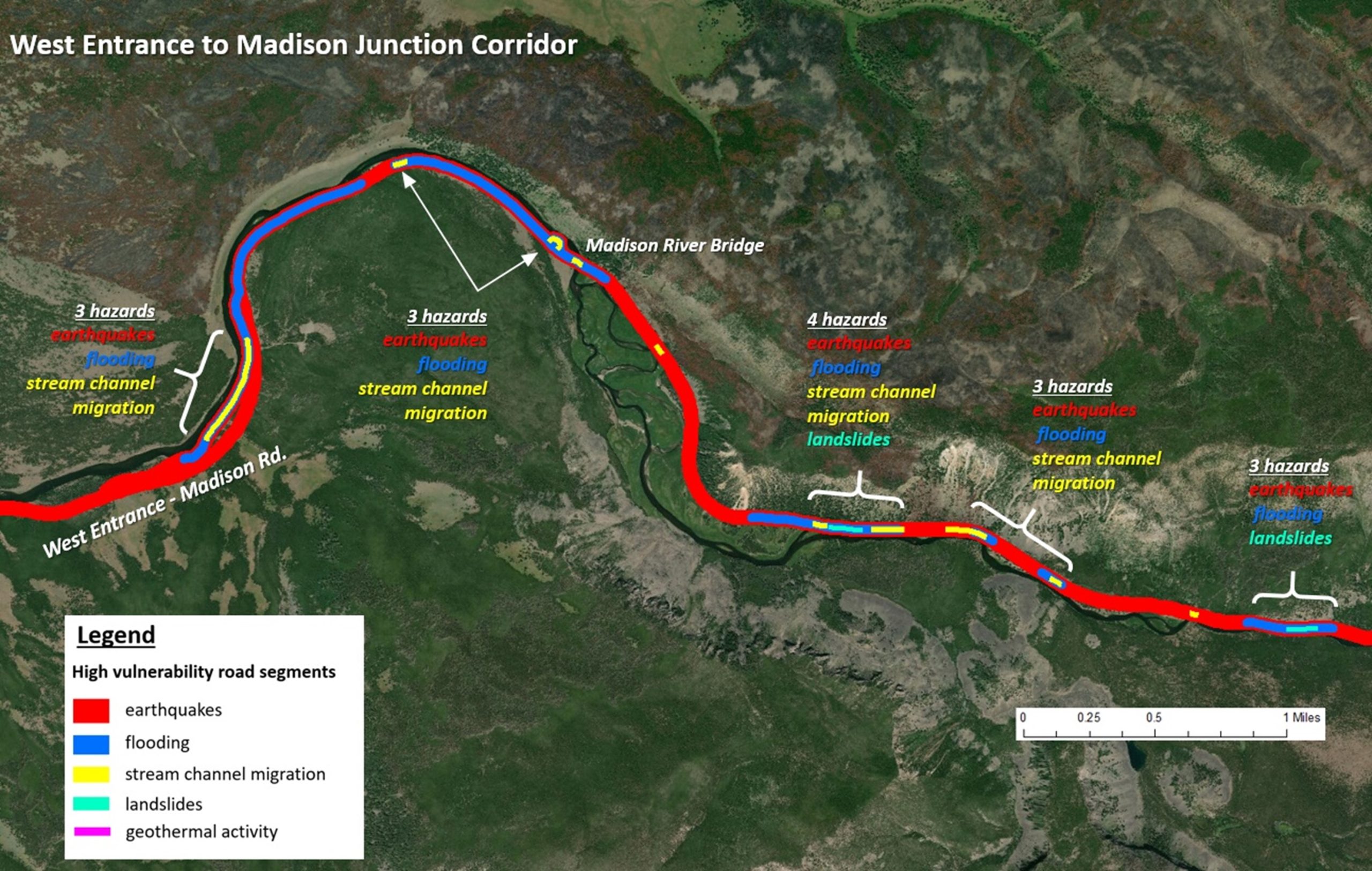
• Natural Hazard Vulnerability of Assets at Yellowstone National Park: This study developed a protocol for assessing the natural hazard vulnerability of assets at Yellowstone National Park, and evaluates the vulnerability of a subset of assets (191 buildings, 34 parking lots, 26 bridges, 78 miles of roads, and 17 miles of trails) to six key natural hazards (flooding, stream channel migration/erosion, geothermal activity, wildfires, landslides, and earthquakes). The project study area encompasses the West Entrance, Madison Junction, Norris, and Old Faithful areas. The primary goals of this project were to 1) present the asset vulnerability assessment protocol and methodologies developed for each natural hazard and asset type at Yellowstone, 2) present the results of the asset vulnerability assessment conducted, including exposure, sensitivity, and final natural hazard vulnerability, 3) provide a synthesis of overall infrastructure vulnerability in the study area, across all six selected natural hazards.

Program for the Study of Developed Shorelines
Old Student Union
Western Carolina University
Cullowhee, NC 28723


