Program for the Study of Developed Shorelines
Science. Policy. Education. Outreach. Coastal.
Coastal Hazards Vulnerability Assessment of Public Infrastructure: Down East & Adjacent Communities, Carteret County, NC
Click Here to Download Full Report
WCU has completed a Coastal Hazards Vulnerability Assessment of Public Infrastructure in Down East Carteret County, including the adjacent communities of South River and Merrimon. This assessment evaluated the vulnerability of infrastructure to coastal flooding, erosion/shoreline proximity, sea-level rise, and storm surge. In total, 67 buildings, 148 state-maintained roads/road segments, and 14 road bridges were analyzed.
Vulnerability is generally defined as the extent to which a resource is susceptible to harm from natural hazard impacts. For infrastructure (assets), vulnerability is most often calculated as a combination of exposure and sensitivity. Exposure refers to the extent or degree to which a natural hazard is likely to affect an asset, and sensitivity refers to how it will fare when exposed to a hazard/impact.
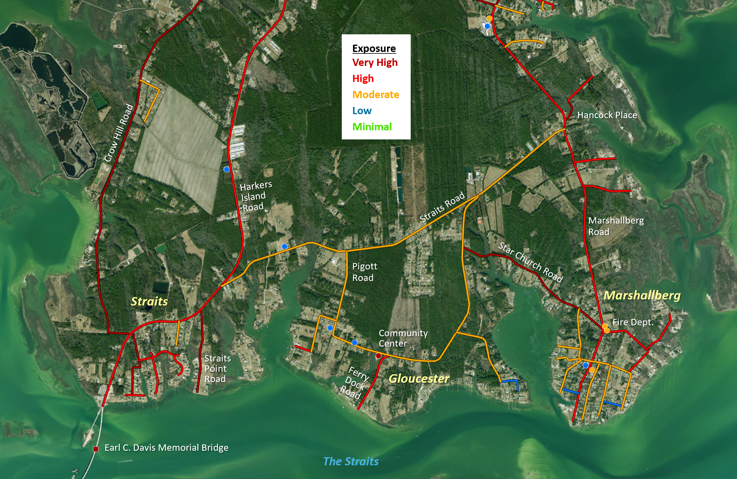
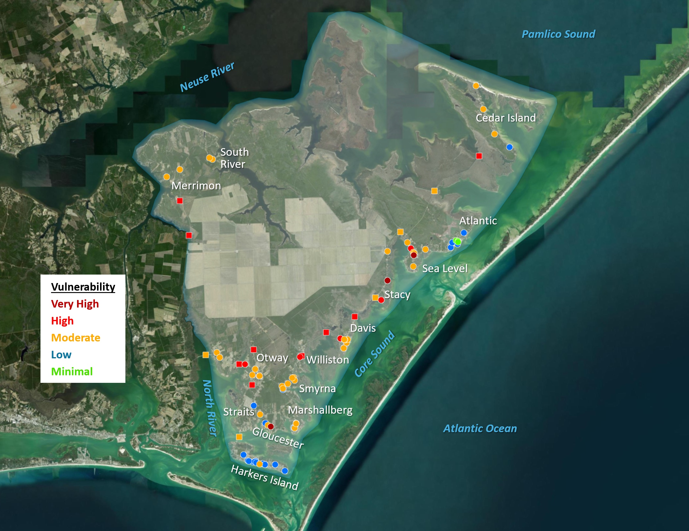
Approximately one-third of all assets analyzed have very high or high exposure to the evaluated coastal hazards, most of which are in the communities of Davis, Merrimon, Otway, Sea Level, Smyrna, Stacy, Straits, and Williston. Over one-third (36%) have moderate exposure, 28% have low exposure, and 2% have minimal exposure (not in any exposure hazard zone). Most of the lower exposure assets are located in Harkers Island or Atlantic. All evaluated bridges have very high exposure. Only 11 buildings have very high or high exposure, and the Original Free Will Baptist Church of Stacy has the highest total exposure indicator (raw) score of any building. Most buildings have either moderate (40%) or low exposure (39%). Three buildings in Atlantic (the Elementary School, United Methodist Church, and Fire Department) have minimal exposure.
Over 50 of the roads analyzed have very high or high exposure, including three roads over five miles in length: Merrimon Road, Cedar Island Road (Old Cedar Island Road to Lola Road), and HWY 70 Stacy.
Cedar Creek Road in Sea Level received the highest possible exposure indicator (raw) score and was the only road or building to fall within the high hazard FEMA VE Zone. Over one-third (38%) of roads have moderate exposure and 25% have low exposure. One road, School Drive in Atlantic, has minimal exposure. Roads were only analyzed for exposure, as sensitivity data were not available (and thus vulnerability could not be calculated).
Approximately one-third of all assets analyzed have very high or high sensitivity, while half have moderate sensitivity, and 14% have low sensitivity. Sea Level Free Will Baptist Church is the only asset with very high sensitivity. Twenty-seven buildings have high sensitivity, including 17 churches, three community centers, and four fire departments/stations. Less than half (45%) of the buildings have moderate sensitivity, while 11% have low sensitivity. The buildings with the lowest total indicator (raw) score for sensitivity are Harkers Island Methodist Church, Trinity United Methodist Church, and Eastern Park – Maintenance & Concessions. No bridges have very high or high sensitivity. The majority (71%) of the bridges have moderate sensitivity, and 29% have low sensitivity. The two lowest sensitivity bridges are Earl C. Davis Memorial Bridge and Commissioner Jonathan Robinson Bridge.
Twenty assets analyzed have very high or high vulnerability to the evaluated coastal hazards. Three buildings have very high vulnerability: Gloucester Community Center, Original Free Will Baptist Church of Stacy, and Sea Level Free Will Baptist Church. No bridges have very high vulnerability, but 10 have high vulnerability. NCDOT (2025) estimates the replacement cost for these high vulnerability bridges at almost $140 million. Nearly half (47%) of the assets have moderate vulnerability, 25% have low vulnerability, and 4% have minimal vulnerability. All but five low vulnerability assets are in Atlantic and Harkers Island, and the only assets with minimal vulnerability are in Atlantic, due to higher elevations.